
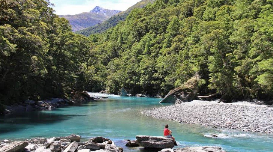
Matukituki Valley is a spectacular alpine valley on New Zealand’s South Island, west of Wānaka in the Otago region. It forms an important gateway into Mount Aspiring National Park, where broad river flats gradually give way to beech forests, alpine grasslands, glaciers, and rugged mountain peaks.
The valley is shaped around the East and West branches of the Matukituki River and is closely associated with Mount Aspiring/Tititea. Its combination of farmland, native forest, braided river landscapes, and high alpine scenery makes it an important destination for hikers, mountaineers, photographers, and visitors exploring the Southern Alps.
Matukituki Valley Quick Facts
| Fact | Details |
|---|---|
| Location | Otago, South Island, New Zealand |
| Country | New Zealand |
| Region | Otago / Southern Alps |
| Valley Elevation | Lower valley is around 300–400 m |
| Main River | Matukituki River |
| Famous For | Alpine scenery, glaciers, hiking and Mount Aspiring |
| Climate | Cool mountain climate with variable rainfall |
| Best Months | Generally November to April |
| Nearby Town | Wānaka |
Where Is Matukituki Valley?
Matukituki Valley is located on the western side of Lake Wānaka in the South Island of New Zealand. It extends westward from the lake toward the Southern Alps and Mount Aspiring National Park.
Wānaka is the main nearby town and the principal service center for visitors heading into the valley. The drive from Wānaka takes about an hour, following the western side of Lake Wānaka before continuing along the Matukituki River toward the park.
The valley has both East and West Matukituki branches. The West Branch provides the main access to popular destinations such as Raspberry Creek and the Rob Roy Glacier area.
Geography and Landscape
Matukituki Valley is a broad mountain valley dominated by the Matukituki River and its two main branches. The river is braided in places and carries water from a network of alpine streams and glaciers before eventually reaching Lake Wānaka.
The lower valley contains open grassland and farmland, while native beech forests become more prominent farther upstream. Above the tree line, the landscape changes to subalpine shrubland, tussock grasslands, rocky slopes, snowfields, and glaciers.
Mount Aspiring/Tititea and surrounding Southern Alps peaks create the dramatic backdrop. The combination of glacial landforms, steep mountain faces, river flats, and alpine vegetation gives the valley a distinctly wild character.
History of Matukituki Valley
Matukituki Valley has a long Māori history. Kāti Māmoe and Kāi Tahu had settlements around the shores of Lake Wānaka and the mouth of the Matukituki River. Māori used the wider region for seasonal food gathering, including resources from forests and waterways.
European exploration began in the nineteenth century. Government surveyor John Turnbull Thomson was the first European known to have seen Mount Aspiring in 1857, while explorer James Hector explored the West Matukituki Valley in 1862.
Farming developed in the valley during the 1870s, and agricultural land remains part of the lower valley landscape today. The wider region later gained increasing importance for recreation, mountaineering, and conservation.
Mount Aspiring National Park was established in 1964, protecting a large area of mountain and river-valley wilderness. The park is also part of Te Wāhipounamu, the South West New Zealand World Heritage Area.
How Was Matukituki Valley Formed?
The valley’s landscape has been strongly influenced by glaciation, erosion, and ongoing mountain-building processes in the Southern Alps. Glaciers repeatedly moved through the region during past ice ages, carving and widening valleys and leaving behind characteristic U-shaped landforms.
Glacial activity also helped create the broad valley floor and surrounding steep mountain terrain. Rivers and streams continue to erode and reshape the landscape, while rockfall and avalanches contribute to changes on the surrounding slopes.
Matukituki Valley Weather Throughout the Year
Matukituki Valley has a changeable mountain climate. Conditions can vary considerably between the lower valley and higher alpine areas, and weather can change quickly during outdoor trips.
January to March
Summer brings the warmest conditions, with longer daylight hours and generally favorable conditions for hiking and sightseeing. Higher mountains can still experience cold temperatures, wind, and sudden changes in weather.
April to June
Autumn brings cooler temperatures and shorter days. Rain becomes more frequent, while snow begins to become increasingly common at higher elevations. Forests and river flats can take on strong seasonal colors.
July to September
Winter is cold, particularly in the alpine areas. Snow and ice can affect higher routes, while avalanche conditions may develop on mountain tracks. Lower valley areas can also experience freezing conditions and occasional snowfall.
October to December
Spring brings rising temperatures and longer days, but mountain weather remains unpredictable. Snow can persist at high elevations, and melting snow contributes to increased water flow in streams and rivers.
Best Weather for Visiting Matukituki Valley
November through April generally offers the most suitable conditions for exploring the valley, particularly for walking and day trips. However, visitors heading into alpine terrain should always check current weather, track, river, and avalanche conditions because conditions can change rapidly.
Things to Do in Matukituki Valley
Hike the Rob Roy Track
The Rob Roy Track is one of the valley’s most popular walks, leading through beech forest and alpine vegetation toward impressive views of Rob Roy Glacier.
Walk to Aspiring Hut
The route from Raspberry Creek to Aspiring Hut follows the West Matukituki Valley through open river flats and native vegetation. It provides an accessible introduction to the area’s longer tramping routes.
Explore the Valley on Foot
Shorter walks and longer tramping routes allow visitors to experience farmland, forests, rivers, tussock-covered slopes, and alpine environments.
Photography
The valley offers extensive opportunities for landscape photography, particularly around the braided river, mountain peaks, glaciers, and changing alpine light.
Mountaineering
Experienced climbers and mountaineers can use the valley as an access point for challenging routes toward Mount Aspiring and surrounding peaks.
Scenic Tours
Scenic flights, helicopter trips, and guided excursions provide opportunities to see glaciers, mountains, and remote parts of the region that are difficult to reach on foot.
Famous Attractions in and Around Matukituki Valley
Mount Aspiring / Tititea
The prominent mountain is the defining peak of the surrounding national park and an important feature of the upper valley landscape.
Rob Roy Glacier
Located above the West Matukituki Valley, Rob Roy Glacier is one of the region’s most accessible glaciers and can be viewed from the Rob Roy Track.
Raspberry Creek
Raspberry Creek is the main road-end access point for several walking and tramping routes entering the national park.
Aspiring Hut
This Department of Conservation hut is an important stopping point on the West Matukituki route and provides access to longer alpine journeys.
West Matukituki River
The river creates a major natural feature through the valley, with braided sections, grassy flats, and mountain views along its course.
Mount Aspiring National Park
The valley provides one of the principal gateways into this large protected wilderness area, known for high mountains, glaciers, forests, and remote river valleys.
Lake Wānaka
The Matukituki River eventually reaches Lake Wānaka, connecting the mountain valley with one of the South Island’s major alpine lakes.
Wildlife and Nature
Beech forest is the dominant native woodland in Matukituki Valley. Red beech is common in warmer valley areas, while mountain beech and silver beech occur in different parts of the valley according to local conditions. Ferns and mosses are common beneath the forest canopy.
Birdlife includes fantails, tomtits, riflemen, kākāriki, paradise shelducks, and other native and introduced species. South Island robins have also been successfully established in parts of the valley. Above the tree line, vegetation becomes increasingly alpine, with tussock grasslands, shrubs, scree, and other hardy plants adapted to exposed conditions.
How to Reach Matukituki Valley
The main approach is from Wānaka via the Wānaka–Mount Aspiring Road. The route follows Lake Wānaka before continuing through the valley toward Raspberry Creek. The journey takes about an hour under normal conditions.
The final section of the road is gravel, and conditions can deteriorate after heavy rain. Some routes and river crossings can become hazardous during adverse weather. There is no railway service into the valley, so private vehicles, tour operators, and local transport services are the practical options.
Where to Stay Near Matukituki Valley
Wānaka is the main accommodation base, offering hotels, motels, lodges, guesthouses, holiday rentals, and campgrounds. Staying in town provides the widest choice of services while keeping the valley within day-trip distance.
Camping and hut accommodation are also available for visitors undertaking longer walks. Aspiring Hut is an important backcountry option, while other huts farther into the national park cater to more experienced trampers and mountaineers.
Why Is Matukituki Valley Famous?
Matukituki Valley is famous for its dramatic combination of braided rivers, native beech forests, glaciers, alpine peaks, and access to Mount Aspiring National Park. Its close connection to Mount Aspiring/Tititea and the Rob Roy Glacier also makes it one of the most important gateways to the Southern Alps around Wānaka.
Matukituki Valley FAQs
Where is Matukituki Valley located?
Matukituki Valley is in Otago on New Zealand’s South Island, west of Lake Wānaka and about an hour’s drive from Wānaka.
What is Matukituki Valley famous for?
It is known for its alpine scenery, glaciers, braided river, native forests, hiking routes, and access to Mount Aspiring National Park.
What is the weather like in Matukituki Valley?
The valley has cool, changeable mountain weather. Summers are generally milder, while winter brings colder conditions and snow at higher elevations.
What are the best months to visit Matukituki Valley?
November through April generally offers the most suitable conditions for hiking and exploring, although weather can change quickly at any time of year.
What can you do in Matukituki Valley?
Visitors can hike, photograph the landscape, explore the river valley, visit glaciers, camp, and undertake more challenging mountaineering routes.
How do you reach Matukituki Valley?
The valley is reached by road from Wānaka along the Wānaka–Mount Aspiring Road. The journey takes about an hour to the main access area.
Does Matukituki Valley get snow?
Yes. Snow is common in the surrounding mountains during winter and can remain at higher elevations well beyond the coldest months.
Can you see Rob Roy Glacier from the valley?
Yes. The Rob Roy Track provides a popular route to viewpoints overlooking Rob Roy Glacier and the surrounding alpine landscape.
Final Thoughts
Matukituki Valley offers a remarkable combination of river flats, forests, glaciers, and high Southern Alps scenery. Its easy connection with Wānaka and its role as a gateway to Mount Aspiring National Park make it an important destination for visitors interested in hiking, nature, photography, and alpine landscapes.
For More Visit Stay And Update
