
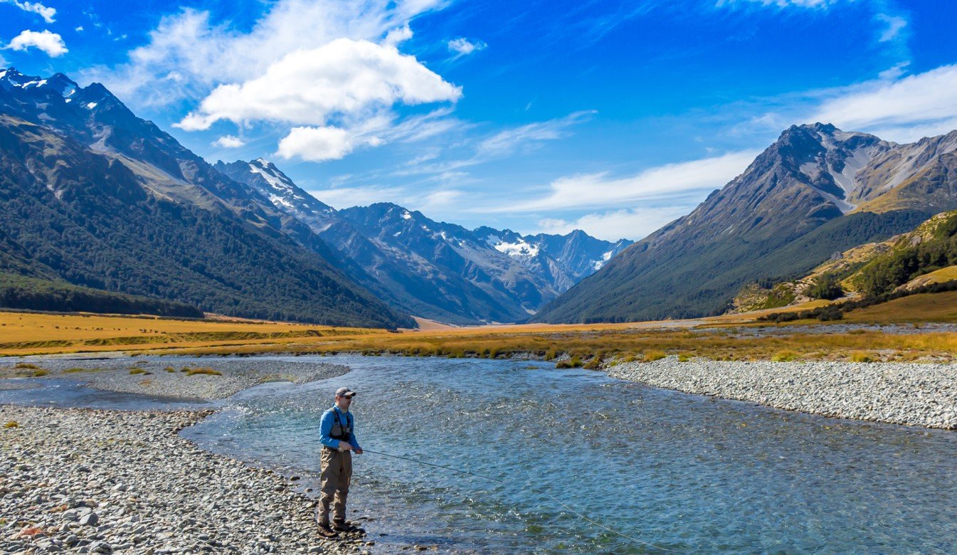
Ahuriri Valley is a remote high-country valley on New Zealand’s South Island, known for its braided river, wide tussock landscapes, wetlands, mountains, and relatively undeveloped character. Located near Omarama in the Waitaki District, the valley forms part of a distinctive inland landscape where farming country gradually gives way to protected conservation land.
The valley is particularly appealing to visitors interested in walking, fishing, mountain scenery, wildlife, and New Zealand’s high-country heritage. Its combination of river flats, beech forest, wetlands, alpine terrain, and historic farming sites gives Ahuriri Valley a character that is different from the country’s more heavily visited mountain destinations.
Ahuriri Valley Quick Facts
| Fact | Details |
|---|---|
| Location | South Island, New Zealand |
| Country | New Zealand |
| Region | Canterbury / Waitaki District |
| Main River | Ahuriri River |
| Landscape | High-country valley, wetlands, mountains and tussocklands |
| Famous For | Braided river, wildlife, conservation land and high-country scenery |
| Climate | Inland mountain climate with cold winters and warm, dry summers |
| Best Months | Generally late spring through early autumn |
| Nearby Town | Omarama |
| Protected Area | Ahuriri Conservation Park |
Where Is Ahuriri Valley?
Ahuriri Valley is in the inland South Island, west of Omarama and near the boundary between the Canterbury and Otago regions. The valley follows the Ahuriri River as it runs through a broad high-country landscape surrounded by mountain ranges.
The main access begins from State Highway 8, with Birchwood Road branching toward the valley approximately 17 kilometres south of Omarama. Omarama is the nearest small service town and an important base for exploring the surrounding high-country area.
The valley extends from relatively accessible farmland and river country into more remote conservation land, giving it a gradual transition from settled rural landscapes to wilderness.
Geography and Landscape
The defining feature of Ahuriri Valley is the Ahuriri River, a braided river flowing through a broad valley surrounded by mountains and extensive tussocklands. Its riverbed, wetlands, backwaters, and surrounding terraces create a varied landscape rather than a single narrow valley corridor.
The surrounding Ahuriri ecological district contains glaciated mountain ranges, extensive wetlands, alpine terrain, scree slopes, tussock grasslands, and remnants of native beech forest. The landscape also contains glacial moraines, outwash gravels, alluvial terraces, and other landforms associated with past ice-age activity.
Elevations vary considerably across the valley. Mountains rise well above the river flats, while peaks such as Ben Avon reach about 1,713 metres. This variation creates noticeably different vegetation and environmental conditions from the valley floor to the alpine areas.
History of Ahuriri Valley
The Ahuriri area has a long association with Māori travel and resource use, followed by the development of European high-country pastoral farming. Its remote valleys became important for sheep stations and seasonal stock management as pastoral settlement expanded through the South Island’s interior.
Quailburn, near the wider Ahuriri area, provides an important reminder of this pastoral history. The historic site includes a woolshed, sheep-dip, homestead remains, and other structures connected with nineteenth-century high-country farming.
The valley’s pastoral heritage remains visible in old musterer’s huts, station landscapes, tracks, and working farmland. Some of these historic places are now protected within the Ahuriri Conservation Park, allowing visitors to see how earlier generations operated in a challenging high-country environment.
Conservation has increasingly become another important part of the valley’s modern identity. Large areas of natural landscape are protected, including wetlands, river habitats, forests, and tussocklands that support native species.
How Was Ahuriri Valley Formed?
Ahuriri Valley’s present landscape was shaped by a combination of glacial activity, river erosion, sediment deposition, and ongoing mountain processes. During past glacial periods, ice moved through the surrounding mountains and valley system, leaving moraines and other glacial landforms behind.
As the climate warmed and the glaciers retreated, meltwater and the Ahuriri River continued to transport and deposit sediment across the valley. The resulting terraces, gravel deposits, wetlands, and braided river channels are important parts of the landscape seen today.
Ahuriri Valley Weather Throughout the Year
Ahuriri Valley has an inland high-country climate, with cold winters, warm summers, and generally drier conditions around the lower valley than in the wetter surrounding mountains. Conditions can change quickly, particularly in higher country.
January to March
Summer is generally the warmest and driest part of the year. Days can be sunny and warm, while nights remain noticeably cooler. Higher elevations can experience much colder conditions than the valley floor.
April to June
Autumn brings cooler temperatures and shorter days. Conditions become increasingly unsettled toward winter, with frost becoming more common and snowfall possible at higher elevations.
July to September
Winter is cold, with regular frost and snow possible across the surrounding mountains. Higher tracks and remote roads can become difficult because of snow, ice, freezing conditions, and winter storms.
October to December
Spring brings gradually warmer conditions, although snow and sudden changes in weather can still occur in the mountains. By late spring, longer daylight hours make walking and outdoor exploration more practical.
Best Weather for Visiting Ahuriri Valley
Late spring through early autumn generally offers the most comfortable conditions for exploring the valley, particularly for walking, cycling, fishing, and sightseeing. Summer provides the warmest weather, while spring and autumn can offer cooler conditions for outdoor activities.
Things to Do in Ahuriri Valley
- Hiking and tramping: Explore tracks through the river valley, wetlands, tussocklands, and conservation areas.
- Mountain biking: Some routes and 4WD tracks provide opportunities for experienced riders.
- Fishing: The Ahuriri River and its tributaries provide opportunities for freshwater fishing.
- Horse riding: Parts of the valley are suitable for horse riding, particularly along accessible high-country tracks.
- Wildlife watching: Wetlands and braided river habitats support several threatened native bird species.
- Photography: The combination of mountains, river channels, tussocklands, wetlands, and historic structures creates varied photographic subjects.
- Scenic exploration: Birchwood Road and surrounding access routes provide opportunities to experience the valley without undertaking a long expedition.
Famous Attractions in and Around Ahuriri Valley
Ahuriri River
The Ahuriri River is the valley’s defining natural feature. Its braided channels and surrounding wetlands create an important river ecosystem and a distinctive high-country landscape.
Ahuriri Conservation Park
This large protected area contains mountains, rivers, tussocklands, forests, wetlands, and historic sites. It provides access to several walking and tramping routes.
Ben Avon Wetland
Located beside Birchwood Road, Ben Avon Wetland is one of the easier natural areas to visit in the valley and provides habitat for wetland and riverbed birds.
Quailburn Historic Site
The Quailburn site preserves important evidence of high-country pastoral farming, including historic buildings and a woolshed.
East Ahuriri Hut
This historic musterer’s hut dates from the nineteenth-century pastoral period. It lies deeper in the valley and forms part of the East Ahuriri route.
Hideaway Hut
Located within Ahuriri Conservation Park, Hideaway Hut is a historic high-country hut reached by a route from the Ahuriri River.
Ben Avon Peak
At approximately 1,713 metres, Ben Avon provides a prominent high-country objective and broad views across the surrounding landscape.
Wildlife and Nature
Ahuriri Valley contains an unusually diverse combination of river, wetland, tussock, forest, and alpine habitats. The braided Ahuriri River provides important breeding and feeding areas for native riverbed birds.
Notable species include the endangered black stilt or kakī, wrybill, black-fronted tern, banded dotterel, and other wetland birds. The surrounding beech forests provide habitat for species including kea and the New Zealand falcon, while native fish such as alpine galaxias and upland bully occur in the river system.
The valley’s wetlands are particularly valuable because they include shallow pools, oxbow ponds, backwaters, swamps, and bog environments. Conservation efforts help protect these habitats from threats such as introduced predators and invasive plants.
How to Reach Ahuriri Valley
The main approach is from State Highway 8 near Omarama. Birchwood Road provides access toward Ahuriri Conservation Park and the upper valley. The lower section is accessible by ordinary vehicles, but farther into the conservation park the road becomes more demanding and a high-clearance four-wheel-drive vehicle may be required.
Upper valley roads can be affected by heavy rain, slips, washouts, snow, and freezing conditions. Visitors heading into remote areas should check current road and weather conditions and be prepared for limited mobile coverage.
Where to Stay Near Ahuriri Valley
Omarama is the most practical nearby base for visitors who want normal accommodation and services before exploring the valley. The town offers accommodation suitable for travelers using it as a base for the surrounding Waitaki and Mackenzie landscapes.
Camping and backcountry huts are also available in appropriate conservation areas, although facilities become increasingly basic as visitors travel deeper into the valley. Anyone planning an overnight trip should check current Department of Conservation conditions and access information before setting out.
Why Is Ahuriri Valley Famous?
Ahuriri Valley is known for its braided river, extensive wetlands, high-country tussock landscapes, mountain scenery, native wildlife, and pastoral heritage. Its relatively remote character and protected conservation areas make it particularly significant as both a natural environment and an example of New Zealand’s South Island high-country landscape.
Ahuriri Valley FAQs
Where is Ahuriri Valley located?
Ahuriri Valley is on New Zealand’s South Island, west of Omarama in the Waitaki District. It extends along the Ahuriri River toward the surrounding high country.
What is Ahuriri Valley famous for?
It is known for the Ahuriri River, wetlands, tussock-covered mountains, native wildlife, conservation areas, and historic high-country farming sites.
What is the weather like in Ahuriri Valley?
The valley has an inland mountain climate, with warm summers, cold winters, frosts, and snow possible in the surrounding higher country.
What are the best months to visit Ahuriri Valley?
Late spring through early autumn generally provides more suitable conditions for outdoor exploration, although mountain weather can change quickly at any time.
What can you do in Ahuriri Valley?
Visitors can hike, tramp, fish, mountain bike, ride horses, photograph the landscape, and observe native wildlife.
How do you reach Ahuriri Valley?
The main access is from State Highway 8 near Omarama via Birchwood Road. The farther reaches require more careful preparation and, on some roads, a high-clearance 4WD vehicle.
Does Ahuriri Valley get snow?
Yes. Snow is possible during winter, particularly at higher elevations. Winter conditions can also affect roads and remote tracks.
What wildlife can be found in Ahuriri Valley?
The valley supports threatened river and wetland birds including black stilt, wrybill, black-fronted tern, and banded dotterel, as well as native fish and forest birds.
Final Thoughts
Ahuriri Valley offers a distinctive view of New Zealand’s South Island high country, combining a braided river system, wetlands, mountains, tussocklands, native wildlife, and a strong pastoral heritage. Its quieter setting makes it particularly suited to visitors interested in nature, outdoor exploration, history, and remote landscapes.
