
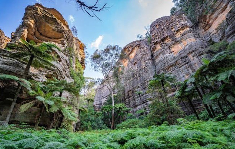
Capertee Valley is a broad rural valley in New South Wales, Australia, known for its dramatic sandstone cliffs, open farmland, eucalyptus forests, and impressive views across the Blue Mountains region. Located west of Sydney, it is often described as one of the world’s widest enclosed valleys, stretching across a landscape shaped by ancient geology and long-term erosion.
The valley offers a quieter alternative to the more heavily visited destinations of the Blue Mountains. Its scenery, birdlife, historic villages, walking trails, and distinctive rock formations make it particularly interesting for travelers interested in nature, photography, geology, and rural Australian landscapes.
Capertee Valley Quick Facts
| Fact | Details |
|---|---|
| Location | Central-western New South Wales, Australia |
| Country | Australia |
| Region | Blue Mountains / Central Tablelands |
| Elevation | Varies across the valley |
| Famous For | Wide sandstone valley, cliffs, wildlife and birdwatching |
| Climate | Temperate with warm summers and cool winters |
| Main Waterway | Capertee River |
| Best Months | March to May and September to November |
| Nearby Town | Capertee |
| Nearest Major City | Sydney |
Where Is Capertee Valley?
Capertee Valley is located in the Central Tablelands of New South Wales, approximately 160 kilometers northwest of Sydney by road. The valley lies west of the main Blue Mountains escarpment and is centered around the township of Capertee.
The area sits between the Blue Mountains and the higher inland tablelands. Other nearby communities include Glen Davis, Lithgow, and Kandos, providing access to accommodation, supplies, and regional attractions.
Geography and Landscape
Capertee Valley is characterized by an exceptionally broad valley floor surrounded by sandstone escarpments, cliffs, ridges, and forested hills. The Capertee River and its tributaries pass through the valley, supporting patches of greener vegetation among the surrounding dry woodland and agricultural land.
The valley is part of the greater Sydney Basin geological region, where layers of sedimentary rock have been exposed and sculpted by erosion. Sandstone cliffs and isolated rock formations are particularly prominent around the valley’s edges.
One of the most recognizable formations is Pantoneys Crown, a distinctive sandstone mesa rising above the surrounding landscape. The combination of open agricultural country and rugged cliffs gives the valley a character quite different from the densely forested mountain scenery found elsewhere in the Blue Mountains.
History of Capertee Valley
The Capertee Valley has a long Indigenous history, with Aboriginal people using and caring for the landscape long before European settlement. The region contains evidence of Aboriginal occupation, including rock shelters, engravings, and other culturally significant sites.
European settlement expanded during the nineteenth century as pastoral activities and mining developed in the surrounding region. Capertee became an important local settlement, while nearby Glen Davis later became associated with the production of shale oil.
The Glen Davis shale industry developed during the twentieth century and attracted workers and infrastructure into the valley. Although the industrial operation eventually closed, its remains now form an important part of the area’s historical landscape.
Today, agriculture, tourism, conservation, and nature-based recreation are important parts of the valley’s identity. Historic remnants and abandoned industrial sites provide a connection between the modern landscape and its earlier economic development.
How Was Capertee Valley Formed?
Capertee Valley’s landscape developed through long periods of erosion acting on the sedimentary rocks of the Sydney Basin. Ancient layers of sandstone and other rocks were gradually exposed as weathering and erosion removed softer material.
The surrounding plateau and escarpments were shaped over geological time, while rivers and streams helped deepen and widen the valley. Continued erosion produced the cliffs, mesas, ridges, and broad valley floor visible today.
Capertee Valley Weather Throughout the Year
Capertee Valley has a temperate inland climate with warm summers, cool winters, and noticeable seasonal variation. Its elevated position means conditions are generally cooler than coastal Sydney.
January to March
Summer and early autumn are generally warm, with daytime temperatures often reaching the mid-to-high 20s Celsius. Thunderstorms can occur during the warmer months, while evenings are usually cooler.
April to June
Autumn brings milder daytime temperatures and increasingly cool nights. By June, winter conditions begin to develop, with colder mornings and occasional frost in lower-lying areas.
July to September
Winter is cool and can be cold overnight, with frost occurring regularly. Daytime conditions are often crisp and suitable for sightseeing and walking, while early spring gradually brings warmer temperatures.
October to December
Spring temperatures rise steadily, although weather can change quickly. Late spring and early summer generally provide pleasant conditions for outdoor activities before the hottest part of summer arrives.
Best Weather for Visiting Capertee Valley
March to May and September to November are generally among the most comfortable periods for exploring Capertee Valley. These months offer milder temperatures than peak summer or winter and are well suited to walking, photography, sightseeing, and wildlife observation.
Things to Do in Capertee Valley
Hiking and Bushwalking
The valley and surrounding escarpments provide opportunities for bushwalking, ranging from shorter walks to more demanding routes through rugged terrain.
Birdwatching
Capertee Valley is particularly well known among birdwatchers. The mixture of woodland, grassland, farmland, and cliffs supports a diverse range of native birds.
Landscape Photography
The wide valley floor, sandstone cliffs, changing light, and distinctive formations such as Pantoneys Crown create excellent opportunities for landscape photography.
Scenic Drives
Driving through the valley provides access to rural landscapes, lookout points, historic areas, and small communities while allowing visitors to appreciate the scale of the surrounding escarpments.
Camping
Camping is available at selected locations in and around the valley, offering a way to experience the rural landscape and night sky.
Exploring Local History
Historic settlements, mining remains, and the former Glen Davis industrial area allow visitors to explore the region’s pastoral and industrial heritage.
Famous Attractions in and Around Capertee Valley
Pantoneys Crown
Pantoneys Crown is one of the valley’s most recognizable geological landmarks. The distinctive flat-topped sandstone formation rises dramatically above the surrounding country.
Glen Davis
Glen Davis is a former shale-oil settlement in the Capertee Valley. Its historic ruins and surrounding bushland provide an unusual combination of industrial history and natural scenery.
Gardens of Stone National Park
Located near the valley, Gardens of Stone National Park contains sandstone pagodas, cliffs, canyons, forests, and unusual rock formations. It is an important area for bushwalking and nature exploration.
Capertee
The small township of Capertee serves as a local center for the valley and provides insight into the area’s rural character and history.
Capertee Valley Lookouts
Several elevated viewpoints around the valley provide broad panoramas of the sandstone escarpments, farmland, forests, and valley floor.
Genowlan Point
Genowlan Point is a prominent area of elevated sandstone country near the western side of the valley, known for its views and distinctive geological environment.
Wildlife and Nature
Capertee Valley contains a mixture of eucalyptus woodland, grassland, farmland, sandstone habitats, and river environments. This variety supports a broad range of native wildlife.
The valley is particularly significant for birdlife and is recognized as an important habitat area for several woodland species. Visitors may encounter parrots, honeyeaters, cockatoos, raptors, and other Australian birds.
Kangaroos and wallabies can occur across open and forested areas, while reptiles and smaller mammals occupy the surrounding woodland and rocky habitats. Conservation areas around the valley protect important native vegetation and provide connected habitat for wildlife.
How to Reach Capertee Valley
Capertee Valley is primarily accessed by road. From Sydney, the usual approach is through the Blue Mountains and Lithgow before continuing toward Capertee. The journey takes several hours depending on the exact destination within the valley.
The nearest significant regional center is Lithgow, which has rail connections to Sydney and other parts of New South Wales. Visitors using public transportation can combine rail travel with road transport for the final part of the journey.
Because many attractions are spread across a large rural area, having a car is the most practical way to explore the valley.
Where to Stay Near Capertee Valley
Accommodation is relatively limited compared with major tourist destinations. Visitors can find rural stays, cottages, farm accommodation, cabins, and camping options in and around the valley.
Lithgow provides a wider selection of hotels, motels, guesthouses, and other accommodation for travelers who prefer more services. Smaller communities near the valley may also offer private cottages and rural lodging.
Why Is Capertee Valley Famous?
Capertee Valley is famous for its immense width, striking sandstone escarpments, distinctive geological formations, birdlife, and combination of rural scenery and industrial history. Its relatively quiet atmosphere also makes it an appealing destination for visitors looking beyond the busier parts of the Blue Mountains.
Capertee Valley FAQs
Where is Capertee Valley located?
Capertee Valley is in central-western New South Wales, Australia, west of the main Blue Mountains and around the township of Capertee.
What is Capertee Valley famous for?
It is known for its broad sandstone landscape, dramatic cliffs, Pantoneys Crown, birdlife, rural scenery, and the historic shale-oil settlement of Glen Davis.
What is the weather like in Capertee Valley?
The valley has warm summers and cool winters, with cold nights and frost possible during winter. Spring and autumn generally have milder conditions.
What are the best months to visit Capertee Valley?
March to May and September to November are generally comfortable periods for outdoor activities because temperatures are moderate.
What can you do in Capertee Valley?
Popular activities include bushwalking, birdwatching, photography, scenic driving, camping, and exploring local history.
How do you reach Capertee Valley?
The valley is mainly reached by road from Sydney via the Blue Mountains and Lithgow. A car is useful because attractions are spread across the region.
Does Capertee Valley get snow?
Snow is possible during cold winter weather, although it is not a regular feature across the valley floor. Frost is more common during winter.
What attractions are near Capertee Valley?
Important nearby attractions include Pantoneys Crown, Glen Davis, Gardens of Stone National Park, Genowlan Point, and viewpoints overlooking the valley.
Final Thoughts
Capertee Valley combines expansive rural scenery with dramatic sandstone geology, diverse birdlife, and a fascinating history shaped by Indigenous culture, pastoral settlement, and mining. It is a rewarding destination for visitors seeking quieter landscapes and a different perspective on the wider Blue Mountains region.
For More Visit Stay And Update
