
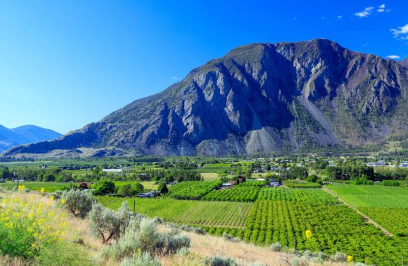
Similkameen Valley is a scenic valley in southern British Columbia, Canada, known for its dry interior climate, mountain landscapes, orchards, vineyards, rivers, and small rural communities. Stretching along the Similkameen River, the valley offers a distinctive combination of rugged wilderness and agricultural land that sets it apart from many other valleys in British Columbia.
The region is closely associated with communities such as Princeton, Keremeos, Cawston, and Hedley. Its landscape supports fruit growing, ranching, vineyards, outdoor recreation, and a growing wine industry, while the surrounding mountains and protected natural areas provide opportunities for hiking, camping, fishing, wildlife viewing, and scenic exploration.
Similkameen Valley Quick Facts
| Fact | Details |
|---|---|
| Location | Southern British Columbia, Canada |
| Country | Canada |
| Region | Similkameen Country / British Columbia Interior |
| Elevation | Varies considerably across the valley |
| Main River | Similkameen River |
| Famous For | Orchards, vineyards, dry climate, mountains and outdoor recreation |
| Climate | Semi-arid to dry continental |
| Best Months | Generally May to October |
| Nearby Towns | Princeton, Keremeos, Cawston and Hedley |
Where Is Similkameen Valley?
Similkameen Valley is located in the southern Interior of British Columbia, west of the Okanagan Valley and close to the United States border. The valley follows the Similkameen River through a largely rural landscape surrounded by mountains.
Princeton lies toward the western part of the valley, while Keremeos and Cawston are farther east. Hedley is another historic community along the Similkameen River. Larger regional centers such as Penticton and Osoyoos provide additional services and transportation connections.
Geography and Landscape
The valley is shaped by the Similkameen River and a series of surrounding mountain ranges. Its landscape changes from forested mountain slopes and rugged canyons to open valley floors containing farms, orchards, vineyards, and ranchland.
Compared with wetter parts of British Columbia, the Similkameen has a notably dry landscape. The rain-shadow effect created by surrounding mountains contributes to warm, dry summers and conditions well suited to agriculture.
The Similkameen River is the valley’s defining waterway. It flows through the region before joining the Okanogan River near the international border. Numerous smaller creeks and tributaries descend from the surrounding mountains.
History of Similkameen Valley
The valley has a long Indigenous history associated with the Similkameen people, whose traditional territory extends across the region. Indigenous communities developed extensive knowledge of the valley’s waterways, plants, animals, and seasonal resources long before European settlement.
European exploration and settlement increased during the nineteenth century, particularly after gold discoveries attracted prospectors to the region. Mining became an important part of the local economy, with Hedley developing as a significant gold-mining community. The historic Mascot Mine near Hedley remains an important reminder of that period.
Agriculture gradually became another defining feature of the valley. The dry climate and warm summers proved suitable for fruit production, particularly around Keremeos and Cawston. Today, farming, ranching, vineyards, tourism, and outdoor recreation all contribute to the region’s economy.
How Was Similkameen Valley Formed?
The valley’s present landscape reflects millions of years of geological activity involving tectonic forces, erosion, uplift, and the movement of rivers through the southern Interior of British Columbia.
The Similkameen River and its tributaries have continued to erode and reshape the terrain, while surrounding mountain ranges influence the valley’s elevation, drainage, and climate. Glacial activity during the Ice Age also affected the broader landscape of the British Columbia Interior.
Similkameen Valley Weather Throughout the Year
Similkameen Valley weather is characterized by relatively dry conditions, warm summers, and cold winters. Conditions vary considerably according to elevation and location within the valley.
January to March
Winter is generally cold, with snow possible across the valley and considerably more snow in surrounding higher elevations. Temperatures gradually begin to rise during March, although winter conditions can continue in the mountains.
April to June
Spring brings warmer temperatures and increasing sunshine. April can still feel cool, while May and June become increasingly pleasant. Orchards and agricultural areas become particularly active as the growing season develops.
July to September
Summer is typically the warmest and driest period. July and August can bring hot afternoons, while evenings are often more comfortable. September remains relatively warm but begins the transition toward cooler autumn conditions.
October to December
Autumn brings cooler temperatures and changing foliage across the surrounding landscape. October can still provide pleasant daytime conditions, while November and December become progressively colder, with increasing chances of snow.
Best Weather for Visiting Similkameen Valley
May through September generally offers the most comfortable weather for exploring the valley, with warm conditions, longer daylight hours, and many outdoor and agricultural attractions operating during the growing season. July and August are particularly suitable for enjoying summer activities, although visitors should be prepared for hot, dry conditions.
Things to Do in Similkameen Valley
- Hiking: Explore trails through mountain landscapes, forests, grasslands, and river environments.
- Cycling: Rural roads and scenic routes provide opportunities for recreational cycling.
- Wine tasting: Visit local vineyards and wineries to experience the valley’s developing wine industry.
- Fruit picking: During the growing season, orchards and farm markets provide opportunities to enjoy locally grown produce.
- Fishing: The Similkameen River and surrounding waterways offer fishing opportunities where permitted and subject to local regulations.
- Camping: Several campgrounds and recreation areas provide access to the valley’s outdoor environment.
- Wildlife watching: Mountain and river habitats support a variety of birds and mammals that can be observed throughout the region.
Famous Attractions in and Around Similkameen Valley
Similkameen River
The river is the central natural feature of the valley and passes through several communities, agricultural areas, and rugged landscapes.
Keremeos
Known for its orchards, fruit stands, and agricultural character, Keremeos is one of the valley’s main communities and an important base for exploring the eastern portion of the region.
Cawston
Cawston is surrounded by farms and orchards and is particularly associated with organic agriculture and the valley’s local food culture.
Hedley
This historic mining community lies along the Similkameen River and preserves connections to the region’s gold-mining past.
Mascot Mine
Located near Hedley, the Mascot Mine is a historic mining site associated with the region’s gold-mining era and provides insight into the difficult conditions faced by earlier miners.
Princeton
Situated at the western end of the valley, Princeton is an important service center and gateway to surrounding wilderness and recreation areas.
Bromley Rock Provincial Park
Located along the Similkameen River near Princeton, Bromley Rock is known for its river scenery, rocky landscape, swimming areas, and recreational setting during suitable conditions.
Cathedral Provincial Park
The rugged mountain wilderness of Cathedral Provincial Park lies south of the valley and is known for alpine landscapes, hiking, and dramatic high-country scenery.
Wildlife and Nature
The valley contains a mixture of dry grasslands, forests, riparian habitats, agricultural areas, and mountainous terrain. This variety supports wildlife adapted to both the relatively dry valley floor and cooler surrounding elevations.
Wildlife in the broader region includes mule deer, black bears, coyotes, beavers, and numerous bird species. The Similkameen River and its tributaries provide important aquatic and riparian habitat, while mountain areas support larger and more diverse forest ecosystems.
Agriculture and natural ecosystems exist side by side throughout much of the valley. Conservation efforts and protected areas help preserve important habitats and maintain ecological connections between the river corridor and surrounding mountains.
How to Reach Similkameen Valley
The valley is primarily accessed by road. Highway 3, also known as the Crowsnest Highway, crosses the region and connects Princeton, Hedley, Keremeos, and other communities.
Travelers can approach from the Okanagan through Highway 3 near Osoyoos or from the west through Hope and Princeton. Penticton Regional Airport and Kelowna International Airport provide the nearest major air connections for many visitors, although a vehicle is generally the most practical way to explore the valley.
Road conditions can change during winter, particularly on mountain routes. Travelers should check current conditions before setting out during periods of snow or severe weather.
Where to Stay Near Similkameen Valley
Accommodation is spread across the valley rather than concentrated in one major resort area. Princeton and Keremeos offer hotels, motels, guesthouses, and other small-scale lodging, while rural areas provide farm stays, cabins, and vacation accommodations.
Camping is another popular option, with provincial parks, recreation areas, and private campgrounds providing different levels of facilities. Staying in one of the valley’s communities can also provide convenient access to restaurants, fuel, groceries, and local attractions.
Why Is Similkameen Valley Famous?
Similkameen Valley is famous for its dry interior climate, agricultural landscapes, orchards, vineyards, Similkameen River, historic mining communities, and mountain scenery. Its combination of rural culture and access to relatively undeveloped wilderness gives the region a distinct character within southern British Columbia.
Similkameen Valley FAQs
Where is Similkameen Valley located?
Similkameen Valley is in southern British Columbia, west of the Okanagan Valley and near the Canada–United States border. Princeton, Keremeos, Cawston, and Hedley are among its main communities.
What is Similkameen Valley famous for?
The valley is known for orchards, vineyards, dry sunny conditions, the Similkameen River, historic mining, ranching, and outdoor recreation.
What is the weather like in Similkameen Valley?
The region has a relatively dry climate, with warm to hot summers and cold winters. Conditions become cooler and snowier at higher elevations.
What are the best months to visit Similkameen Valley?
May through September generally offers favorable conditions for sightseeing, hiking, cycling, agriculture-related visits, and other outdoor activities.
What can you do in Similkameen Valley?
Visitors can hike, cycle, camp, fish, explore historic sites, visit wineries, enjoy local farms, and experience the surrounding mountain landscapes.
How do you reach Similkameen Valley?
Highway 3 is the main road through the valley. The region can be reached from the Okanagan or from the west through Hope and Princeton.
Does Similkameen Valley get snow?
Yes. Snow occurs during winter, particularly at higher elevations, although the amount varies considerably depending on location and elevation.
Which towns are in Similkameen Valley?
Princeton, Hedley, Keremeos, and Cawston are among the best-known communities in the valley.
Final Thoughts
Similkameen Valley offers a distinctive combination of dry interior landscapes, agriculture, river scenery, mountain wilderness, and history. Its communities provide a quieter alternative to larger British Columbia destinations, while the surrounding countryside offers plenty of opportunities for outdoor recreation and exploration.
For More Visit Stay And Update
