
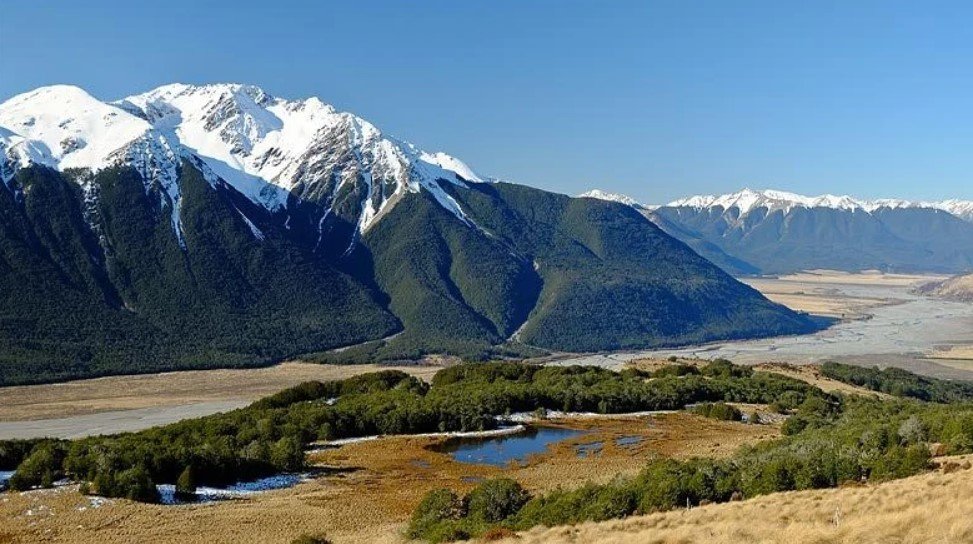
Waimakariri Valley is a broad and scenic river valley on New Zealand’s South Island, shaped by the Waimakariri River and surrounded by the Southern Alps and foothills of the Canterbury region. The valley provides a transition between the high mountain landscapes inland and the more open plains toward Christchurch.
The area is known for its rivers, alpine scenery, forests, farmland, and access to outdoor recreation. Its landscape changes considerably from the upper reaches near the mountains to the lower valley, where the river eventually crosses the Canterbury Plains. The combination of rugged terrain and relatively easy access from Christchurch makes the valley an important natural and recreational area.
Waimakariri Valley Quick Facts
| Fact | Details |
|---|---|
| Location | Canterbury, South Island, New Zealand |
| Country | New Zealand |
| Region | Canterbury |
| Main River | Waimakariri River |
| Landscape | Alpine valley, foothills, river plains and farmland |
| Famous For | Waimakariri River, mountain scenery and outdoor recreation |
| Climate | Temperate, with cooler alpine conditions inland |
| Best Months | Generally November to March |
| Nearby City | Christchurch |
| Notable Settlement | Oxford and surrounding Canterbury communities |
Where Is Waimakariri Valley?
Waimakariri Valley is in the Canterbury region of New Zealand’s South Island, northwest of Christchurch. The valley follows the Waimakariri River as it flows from the Southern Alps toward the Canterbury Plains and the Pacific Ocean.
The upper valley extends into a mountainous area west of the Canterbury foothills, while the lower reaches open toward agricultural land. Christchurch is the nearest major city and serves as the principal gateway for visitors exploring the wider region.
Geography and Landscape
The Waimakariri River is the defining geographical feature of the valley. It rises in the Southern Alps and travels eastward through a landscape that includes steep mountain slopes, river terraces, gravel beds, foothills, and open farmland.
The upper Waimakariri landscape is distinctly alpine, with rugged peaks, braided river channels, and valleys formed by glaciers and flowing water. Further east, the terrain becomes lower and more open as the river approaches the Canterbury Plains.
The valley is also connected with several mountain and recreational areas, including the Craigieburn Range and Arthur’s Pass region. Its varied elevation creates noticeably different landscapes over relatively short distances.
History of Waimakariri Valley
The history of the valley is closely connected to Māori use of the wider Canterbury landscape. The Waimakariri River was an important geographical feature for Ngāi Tahu, the principal Māori iwi of the South Island, and its name reflects the area’s Māori heritage.
European settlement expanded across Canterbury during the nineteenth century. Agriculture became particularly important on the lower land surrounding the river, while the mountainous upper country remained more strongly associated with pastoral activity, exploration, transport, and recreation.
The development of roads and railways through Canterbury improved access to the inland valleys and helped connect communities with Christchurch and other parts of the South Island. In later decades, the region became increasingly important for tourism and outdoor recreation, particularly because of its proximity to alpine landscapes and national park areas.
How Was Waimakariri Valley Formed?
The valley’s landscape developed through a combination of glacial erosion, river erosion, tectonic uplift, and sediment deposition. The Southern Alps have been uplifted by movement along the Alpine Fault, while glaciers and rivers have progressively carved and reshaped the surrounding terrain.
During colder periods of the Ice Age, glaciers occupied parts of the upper Waimakariri basin. As the climate warmed and the ice retreated, meltwater and the river system continued transporting enormous quantities of gravel and sediment toward the Canterbury Plains. This helped create the broad river channels and terraces visible across parts of the region today.
Waimakariri Valley Weather Throughout the Year
Waimakariri Valley weather varies significantly with elevation. The lower valley and foothills have a temperate Canterbury climate, while the upper valley experiences colder alpine conditions, greater precipitation, and winter snow.
January to March
Summer generally brings the warmest and driest conditions, particularly in the lower parts of the valley. Days can be pleasant for hiking, sightseeing, camping, and river-based recreation, although weather can change quickly in the mountains.
April to June
Autumn brings cooler temperatures and shorter days. Higher elevations become increasingly cold, and rainfall becomes more frequent. The changing vegetation around the foothills can create attractive autumn scenery.
July to September
Winter is the coldest period, with snow common in the surrounding mountains and higher parts of the valley. Lower elevations can remain relatively accessible, but alpine roads and tracks may experience snow, ice, or difficult conditions.
October to December
Spring brings gradually warmer temperatures and longer daylight hours. Snow remains on higher mountains early in the season, while lower areas become greener. Rainfall and rapidly changing mountain weather remain possible.
Best Weather for Visiting Waimakariri Valley
November through March generally offers the most comfortable conditions for exploring the valley, particularly for hiking, camping, sightseeing, and other outdoor activities. Visitors heading into higher alpine areas should still prepare for sudden changes in weather regardless of season.
Things to Do in Waimakariri Valley
Hiking and Tramping
The valley and surrounding foothills provide access to walking and tramping routes ranging from relatively easy tracks to demanding alpine journeys.
Rafting and River Recreation
The Waimakariri River is well known for white-water recreation, particularly in its more rugged upper sections. Guided rafting is an option for visitors seeking an active experience.
Camping
Several camping opportunities are available around the wider valley and nearby mountain areas, allowing visitors to stay close to forests, rivers, and alpine scenery.
Fishing
The Waimakariri River and other waterways in the wider Canterbury region provide opportunities for freshwater fishing where permitted.
Mountain Biking
Tracks and trails in the surrounding foothills and mountain areas provide opportunities for mountain biking, with routes varying in difficulty.
Photography
The combination of braided river channels, mountain peaks, forests, farmland, and changing alpine weather makes the valley well suited to landscape photography.
Famous Attractions in and Around Waimakariri Valley
Waimakariri River
The river is the defining feature of the valley and one of Canterbury’s major waterways. Its braided channels and mountain backdrop create some of the region’s most recognizable landscapes.
Arthur’s Pass
Arthur’s Pass is a mountain settlement and major alpine crossing between Canterbury and the West Coast. It provides access to spectacular mountain scenery, walking tracks, and the wider Arthur’s Pass National Park.
Arthur’s Pass National Park
This protected alpine landscape contains mountains, forests, rivers, valleys, and native wildlife. It is one of the principal natural areas associated with the upper Waimakariri region.
Craigieburn Range
The Craigieburn Range forms part of the mountainous landscape west of the Canterbury Plains and is known for its rugged peaks, walking routes, and winter recreation.
Oxford
Oxford is a small rural town north of the Waimakariri River and provides access to the foothills, farmland, forests, and outdoor attractions of northern Canterbury.
Castle Hill
Castle Hill is a distinctive limestone landscape featuring unusual rock formations scattered across an open basin. It is one of the most recognizable natural attractions in the wider Canterbury high-country region.
Kura Tāwhiti Conservation Area
Also known as Castle Hill Conservation Area, this protected landscape combines limestone formations with cultural significance and extensive walking opportunities.
Wildlife and Nature
The Waimakariri Valley contains several contrasting ecosystems, from braided river environments and grasslands to native forests and alpine habitats. The higher country supports plants adapted to colder conditions, while lower areas contain a mixture of farmland and regenerating native vegetation.
Birdlife is an important part of the region’s natural environment. Species found in the wider Canterbury and alpine areas include kea, New Zealand falcons, South Island pied oystercatchers, and other native birds. The river and wetland environments also provide habitat for water-associated species.
Conservation areas and national parklands around the upper valley help protect native ecosystems from development and introduced predators. The alpine environment is particularly valuable because it contains plant and animal communities adapted to harsh mountain conditions.
How to Reach Waimakariri Valley
Christchurch is the main transportation gateway to the region. From the city, travelers can drive north and west through Canterbury toward the foothills and upper Waimakariri area.
State Highway 73 is the principal route toward Arthur’s Pass and the upper Waimakariri region. The road continues across Arthur’s Pass toward the West Coast. Rail services also operate between Christchurch and Arthur’s Pass as part of the TranzAlpine route, providing a scenic alternative to driving.
Winter conditions can affect higher roads, particularly around Arthur’s Pass. Snow, ice, heavy rain, and rockfalls can occasionally cause delays or temporary closures, so road conditions should be checked before traveling.
Where to Stay Near Waimakariri Valley
Accommodation is available in several communities and recreation areas around the valley. Arthur’s Pass provides a useful base for exploring the upper mountain country, with accommodation and camping facilities available in the surrounding area.
Oxford and other Canterbury foothill communities offer additional guesthouses, holiday accommodation, farm stays, and camping options. Travelers looking for a wider selection of hotels and services can stay in Christchurch and make day trips into the valley.
Why Is Waimakariri Valley Famous?
Waimakariri Valley is best known for the Waimakariri River and the striking transition from Canterbury’s open plains to the rugged Southern Alps. Its braided river landscapes, alpine scenery, outdoor recreation, Māori heritage, and proximity to Arthur’s Pass make it an important natural and recreational destination in Canterbury.
Waimakariri Valley FAQs
Where is Waimakariri Valley located?
Waimakariri Valley is in Canterbury on New Zealand’s South Island, northwest of Christchurch. It follows the Waimakariri River from the Southern Alps toward the Canterbury Plains.
What is Waimakariri Valley famous for?
The valley is particularly known for the Waimakariri River, braided waterways, mountain scenery, alpine landscapes, and outdoor recreation.
What is the weather like in Waimakariri Valley?
The lower valley has a temperate climate, while higher areas are colder and receive more precipitation and winter snow. Mountain weather can change quickly.
What are the best months to visit Waimakariri Valley?
November through March generally provides the most favorable conditions for outdoor activities, although the best period depends on the specific part of the valley and activities planned.
What can you do in Waimakariri Valley?
Visitors can hike, camp, fish, photograph the landscape, enjoy mountain biking, and take part in river-based activities such as rafting.
How do you reach Waimakariri Valley?
The valley is primarily reached by road from Christchurch. State Highway 73 provides access toward the upper valley and Arthur’s Pass, while the TranzAlpine train provides rail access to Arthur’s Pass.
Does Waimakariri Valley get snow?
Yes. Snow is common in the surrounding mountains and higher elevations during winter, although conditions are generally milder on the lower valley floor.
What attractions are near Waimakariri Valley?
Arthur’s Pass, Arthur’s Pass National Park, the Craigieburn Range, Castle Hill, Kura Tāwhiti, and the town of Oxford are among the notable places in the wider area.
Final Thoughts
Waimakariri Valley offers a distinctive view of Canterbury, where a powerful braided river connects the agricultural plains with the mountains of the Southern Alps. Its combination of natural scenery, outdoor recreation, cultural heritage, and access to alpine areas makes it a worthwhile destination for travelers and anyone interested in New Zealand’s diverse valley landscapes.
For More Visit Stay And Update
