
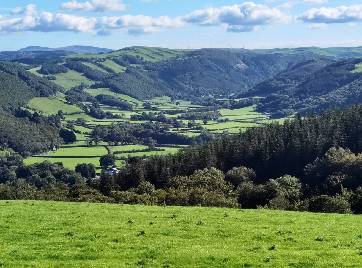
Rheidol Valley is a scenic river valley in mid-Wales, shaped by the River Rheidol as it flows through the Cambrian Mountains toward the west coast. Known for its wooded hillsides, waterfalls, reservoirs, rugged landscapes, and historic communities, the valley is one of the most distinctive natural areas around Aberystwyth and the surrounding Ceredigion countryside.
The valley combines natural scenery with a long industrial and transport history. Visitors can explore waterfalls, reservoirs, woodland paths, historic mining landscapes, and the famous Vale of Rheidol Railway, which travels between Aberystwyth and Devil’s Bridge through some of the region’s most dramatic scenery.
Rheidol Valley Quick Facts
| Fact | Details |
|---|---|
| Location | Ceredigion, Mid Wales |
| Country | Wales, United Kingdom |
| Region | Cambrian Mountains and Ceredigion |
| Main River | River Rheidol |
| Famous For | Waterfalls, reservoirs, railway and wooded mountain scenery |
| Climate | Temperate maritime |
| Landscape | Woodland, hills, river valleys and upland terrain |
| Best Months | May to September |
| Nearby Town | Aberystwyth |
| Notable Landmark | Devil’s Bridge |
Where Is Rheidol Valley?
Rheidol Valley is in Ceredigion, in western mid-Wales. The valley follows the River Rheidol from the upland areas of the Cambrian Mountains toward Aberystwyth, where the river reaches Cardigan Bay.
Aberystwyth is the principal town associated with the valley and provides an important base for exploring the area. Devil’s Bridge lies farther inland, near the upper part of the valley, while smaller settlements and rural communities are scattered throughout the surrounding countryside.
Geography and Landscape
The Rheidol Valley is defined by a combination of steep wooded slopes, open uplands, river scenery, waterfalls, reservoirs, and narrow valleys. The River Rheidol is one of the valley’s central geographical features, flowing through a landscape that becomes increasingly rugged away from the coast.
The valley also contains several important water bodies, including reservoirs associated with the Rheidol hydroelectric system. The surrounding Cambrian Mountains provide an upland backdrop, while woodland and rocky sections of the river create a varied landscape.
One of the most dramatic natural features is the series of waterfalls around Devil’s Bridge and the Mynach Gorge. Here, the River Mynach drops through a steep gorge before joining the Rheidol.
History of Rheidol Valley
The history of Rheidol Valley is closely connected with agriculture, rural communities, transportation, and mineral extraction. The surrounding hills contain evidence of centuries of human activity, while lead and other metal mining became particularly important in the region during the nineteenth century.
Mining shaped settlements and transportation routes across the valley. Remains of old workings, tracks, spoil heaps, and other industrial features can still be found in parts of the wider Rheidol and Cambrian Mountain landscape.
Transportation also became central to the valley’s development. The Vale of Rheidol Railway was constructed to connect Aberystwyth with the inland communities and mineral-producing areas. The narrow-gauge railway later became an important heritage attraction and continues to carry passengers between Aberystwyth and Devil’s Bridge.
How Was Rheidol Valley Formed?
The valley’s landscape reflects the long-term effects of erosion, river action, and the geological processes that shaped the Cambrian Mountains. The River Rheidol and its tributaries have progressively cut through the surrounding terrain, creating the valley and its associated gorges.
Glacial activity during the Ice Age also influenced the wider upland landscape of mid-Wales. In the narrower sections around the river and its tributaries, ongoing erosion continues to shape waterfalls, gorges, and rocky river channels.
Rheidol Valley Weather Throughout the Year
Rheidol Valley has a temperate maritime climate, influenced by its position in western Wales. Rainfall is relatively common throughout the year, while temperatures are generally moderate compared with continental climates.
January to March
Winter and early spring are cool and often wet. Higher ground around the valley can feel considerably colder, and rain, strong winds, and occasional frost are possible. The wetter conditions can make waterfalls and rivers particularly impressive.
April to June
Spring brings gradually warmer temperatures and longer daylight hours. Rain remains possible, but woodland begins to develop fresh foliage and the countryside becomes increasingly green. May and June are generally good months for walking and sightseeing.
July to September
Summer is usually the warmest period, although the maritime climate means conditions can change quickly. Rain showers remain possible, making waterproof clothing useful even during summer visits. Longer daylight hours provide more time for exploring the valley and surrounding attractions.
October to December
Autumn brings cooler temperatures, increasing rainfall, and changing woodland colors. By November and December, shorter days and wetter weather become more common, while higher elevations can experience colder conditions.
Best Weather for Visiting Rheidol Valley
May through September generally offers the most comfortable conditions for exploring the valley, with longer days and milder temperatures. Spring and early summer are particularly appealing for woodland scenery, while autumn is a good choice for visitors interested in seasonal colors.
Things to Do in Rheidol Valley
Ride the Vale of Rheidol Railway
A journey on the historic narrow-gauge railway is one of the area’s signature experiences. The route links Aberystwyth with Devil’s Bridge and provides views of the valley’s changing landscapes.
Walk Through Woodland and Countryside
Numerous walking routes explore the valley, surrounding hills, and river landscapes. Paths range from relatively gentle walks to more demanding routes in the upland countryside.
Visit Waterfalls
The valley’s rivers and tributaries create several waterfalls and cascades, particularly around Devil’s Bridge and the Mynach Gorge.
Explore Reservoirs
The Rheidol hydroelectric system created a series of reservoirs surrounded by upland scenery. These areas provide opportunities for quiet sightseeing and walking.
Photograph the Landscape
Woodland, rivers, waterfalls, hills, historic structures, and changing weather provide varied photography opportunities throughout the year.
Explore Local History
Visitors interested in industrial heritage can investigate former mining landscapes and historic transportation routes around the valley.
Famous Attractions in and Around Rheidol Valley
Devil’s Bridge
Devil’s Bridge is the valley’s best-known landmark. Three bridges, built at different periods, cross the steep gorge of the River Mynach, creating a unique historical and architectural attraction.
Mynach Falls
Mynach Falls plunges dramatically through the gorge at Devil’s Bridge. The waterfall is closely associated with the area’s most famous natural scenery.
Vale of Rheidol Railway
This heritage railway runs from Aberystwyth to Devil’s Bridge, following the Rheidol Valley through wooded hills and upland scenery.
Rheidol Hydro Scheme
The Rheidol hydroelectric system includes reservoirs and infrastructure set within the surrounding mountain landscape, combining modern engineering with the area’s natural environment.
Aberystwyth
At the western end of the valley, Aberystwyth provides access to the Rheidol landscape as well as coastal attractions, historic buildings, shops, and cultural facilities.
Cambrian Mountains
The wider Cambrian Mountains form the upland setting around the valley and offer extensive opportunities for exploring open countryside, hills, reservoirs, and remote landscapes.
Wildlife and Nature
Rheidol Valley supports a mixture of woodland, river, grassland, and upland habitats. The varied terrain provides environments for birds, mammals, insects, and native plant communities, while the river system contributes to the area’s ecological diversity.
Birds of prey and woodland birds can be seen across the wider Ceredigion and Cambrian Mountain region, while rivers and streams provide habitats for aquatic species. The surrounding countryside is also important for native vegetation, particularly in less intensively managed upland areas.
How to Reach Rheidol Valley
Aberystwyth is the principal transport hub for the valley. The town is connected to the national rail network through Aberystwyth railway station, with onward connections to other parts of Wales and England.
By road, the valley can be approached from Aberystwyth and surrounding Ceredigion communities. Devil’s Bridge is accessible by road from Aberystwyth, while the Vale of Rheidol Railway provides a scenic alternative for reaching the inland end of the valley.
Because many roads in the upper valley are rural and narrow, drivers should allow extra time and check conditions before traveling, particularly during wet or wintry weather.
Where to Stay Near Rheidol Valley
Aberystwyth offers the widest range of accommodation, including hotels, guesthouses, bed-and-breakfasts, self-catering properties, and holiday apartments. Staying there is convenient for visitors who want access to both the valley and the coast.
For a quieter rural experience, accommodation can also be found in villages and countryside around Devil’s Bridge and the upper Rheidol Valley. Campsites, cottages, and rural guesthouses are suitable options for visitors who prefer to stay closer to the surrounding landscape.
Why Is Rheidol Valley Famous?
Rheidol Valley is famous for its combination of dramatic river scenery, the waterfalls and bridges at Devil’s Bridge, the historic Vale of Rheidol Railway, and the rugged landscapes of the Cambrian Mountains. Its blend of natural scenery and industrial heritage gives the valley a character that is distinctly Welsh.
Rheidol Valley FAQs
Where is Rheidol Valley located?
Rheidol Valley is in Ceredigion, mid-Wales, extending inland from Aberystwyth toward the Cambrian Mountains and Devil’s Bridge.
What is Rheidol Valley famous for?
It is best known for Devil’s Bridge, Mynach Falls, the Vale of Rheidol Railway, reservoirs, wooded hills, and mountain scenery.
What is the weather like in Rheidol Valley?
The valley has a mild maritime climate with rainfall possible throughout the year. Summers are generally mild, while winters are cooler and wetter.
What are the best months to visit Rheidol Valley?
May through September generally provides the most favorable conditions for walking, sightseeing, and railway journeys, although the valley can be visited throughout the year.
What can you do in Rheidol Valley?
Popular activities include walking, sightseeing, photography, visiting waterfalls, exploring historic sites, and riding the Vale of Rheidol Railway.
How do you reach Rheidol Valley?
Aberystwyth provides the main access point by road and rail. Devil’s Bridge can be reached by road, while the Vale of Rheidol Railway connects it with Aberystwyth.
Does Rheidol Valley get snow?
Snow is possible during winter, particularly on higher ground in the surrounding Cambrian Mountains, although conditions vary from year to year.
What attractions are near Rheidol Valley?
Major attractions include Devil’s Bridge, Mynach Falls, the Vale of Rheidol Railway, Rheidol reservoirs, Aberystwyth, and the wider Cambrian Mountains.
Final Thoughts
Rheidol Valley offers a compact introduction to the landscapes and heritage of mid-Wales, combining a powerful river system, wooded hills, waterfalls, reservoirs, historic mining areas, and a renowned heritage railway. Its proximity to Aberystwyth also makes it an accessible destination for exploring both inland and coastal Ceredigion.
For More Visit Stay And Update
