
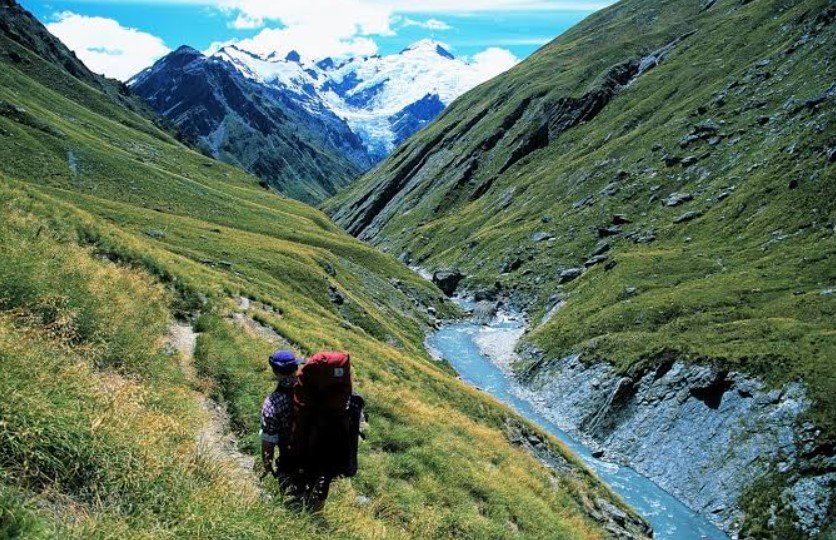
Rees Valley is a scenic alpine valley in New Zealand’s South Island, stretching from the shores of Lake Wakatipu into the mountainous interior of the Otago region. The valley follows the Rees River through a landscape of rugged mountains, open grasslands, native vegetation, and remote backcountry terrain.
Known for its dramatic Southern Alps scenery and access to some of New Zealand’s most spectacular wilderness areas, Rees Valley is particularly appealing to hikers, photographers, anglers, and travelers looking for a quieter alternative to more developed destinations around Queenstown.
Rees Valley Quick Facts
| Fact | Details |
|---|---|
| Location | Otago, South Island, New Zealand |
| Country | New Zealand |
| Region | Otago |
| Main River | Rees River |
| Elevation | Varies considerably from Lake Wakatipu to the surrounding mountains |
| Famous For | Alpine scenery, hiking, wilderness and the Rees River |
| Climate | Cool alpine and temperate mountain climate |
| Best Months | Generally November to April |
| Nearby Town | Glenorchy |
| Nearby Major City | Queenstown |
Where Is Rees Valley?
Rees Valley is located in the southwestern part of New Zealand’s South Island, north of Queenstown and close to the small settlement of Glenorchy. The valley begins near the northern end of Lake Wakatipu and extends northward toward the mountainous interior.
Its location places it within a remote part of the Southern Alps, with Glenorchy serving as the principal gateway for travelers heading into the valley. Queenstown is the nearest major tourist center and provides the area’s main transport, accommodation, and visitor services.
Geography and Landscape
The valley follows the Rees River between major mountain ranges and contains a mixture of river flats, tussock-covered slopes, beech forests, steep alpine terrain, and high mountain peaks. The river eventually flows into Lake Wakatipu near Glenorchy.
The surrounding landscape is strongly influenced by the Southern Alps, creating a dramatic contrast between the relatively open valley floor and the steep mountains rising on either side. Higher areas contain rugged ridges, alpine vegetation, snowfields, and remote passes.
The Rees Valley also forms part of an important wilderness corridor connecting the Lake Wakatipu area with the mountainous interior of Fiordland and Mount Aspiring National Park.
History of Rees Valley
The wider region around Rees Valley has a long Māori history. Māori traveled through the South Island using established routes for seasonal movement, hunting, gathering, and access to valuable resources.
European exploration and settlement increased during the nineteenth century, particularly after gold was discovered in the Otago region. Prospectors explored remote valleys and rivers throughout the area, although the Rees Valley remained primarily associated with pastoral activity rather than becoming a major gold-mining settlement.
Sheep farming subsequently became an important part of the valley’s history. Today, the area retains a strong connection with high-country farming while also being valued for recreation, conservation, and wilderness tourism.
How Was Rees Valley Formed?
Rees Valley was shaped primarily by the geological and glacial processes that formed much of the Southern Alps. Uplift along the Alpine Fault raised the surrounding mountains, while glaciers repeatedly moved through the region during the Ice Ages.
Glacial erosion widened and deepened existing valleys, leaving the broad U-shaped forms and steep mountain walls visible today. Rivers and ongoing erosion continue to modify the valley floor and surrounding slopes.
Rees Valley Weather Throughout the Year
Rees Valley has a variable mountain climate. Weather can change quickly, particularly as conditions move across the Southern Alps. Rain, strong winds, snow, and sudden temperature changes are possible even during warmer months.
January to March
Summer provides some of the warmest and generally most settled conditions. Days can be pleasant for hiking, while nights remain cool. Rainfall is still possible and mountain weather can change rapidly.
April to June
Autumn brings cooler temperatures and shorter daylight hours. The surrounding forests and mountains can take on seasonal color, while rainfall and unsettled conditions become more common. Snow may begin appearing at higher elevations.
July to September
Winter is cold, with frequent snow at higher elevations and potentially difficult conditions on mountain routes. Freezing temperatures, snow, ice, and shorter daylight hours make backcountry travel more demanding.
October to December
Spring gradually brings warmer conditions, but snow can remain on the surrounding peaks. Melting snow contributes to higher river flows, while weather can remain changeable throughout the season.
Best Weather for Visiting Rees Valley
November through April generally offers the most suitable conditions for hiking and exploring the valley, with longer daylight hours and easier access to backcountry routes. Summer is particularly popular, although visitors should always prepare for rapidly changing mountain weather.
Things to Do in Rees Valley
Rees-Dart Track
The Rees-Dart Track is the valley’s signature hiking experience. This multi-day Great Walk-style route follows the Rees and Dart river valleys through forests, grasslands, and dramatic mountain country.
Hiking and Tramping
Shorter walks and longer backcountry trips allow visitors to explore the valley at different levels of difficulty. Experienced hikers can venture farther into the surrounding mountain terrain.
Fishing
The Rees River is known for trout fishing, making it an attractive destination for anglers. Visitors must follow New Zealand’s applicable fishing regulations and licensing requirements.
Photography
The combination of rivers, mountains, forests, open tussock country, and changing light makes the valley particularly suitable for landscape photography.
Wildlife Watching
Quiet areas of the valley provide opportunities to observe native birds and other wildlife. Early mornings and less-developed areas are generally the best places for nature observation.
Scenic Driving
The road toward Rees Valley provides changing views of Lake Wakatipu, Glenorchy, farmland, river landscapes, and the surrounding mountains.
Famous Attractions in and Around Rees Valley
Rees River
The Rees River is the defining waterway of the valley, flowing through the mountain landscape before reaching Lake Wakatipu near Glenorchy.
Rees-Dart Track
This well-known backcountry route connects the Rees and Dart valleys and provides access to some of the region’s most impressive alpine scenery.
Lake Wakatipu
The long, narrow lake forms the southern setting of the valley and is one of the most recognizable natural landmarks in the Queenstown-Glenorchy region.
Glenorchy
Glenorchy is the main settlement near Rees Valley and serves as a gateway to several walking tracks and wilderness areas.
Mount Aspiring National Park
The valley lies close to one of New Zealand’s major protected mountain landscapes. The park contains glaciers, alpine peaks, forests, rivers, and extensive wilderness.
Paradise
The Paradise area near Glenorchy is known for its rural landscapes, beech forests, and views toward the surrounding mountains. It also provides access to several outdoor destinations in the region.
Wildlife and Nature
Rees Valley supports ecosystems typical of the South Island’s mountain environment. Native beech forests occur in suitable areas, while higher elevations transition into tussock grasslands and alpine vegetation.
Birdlife includes native species found throughout the southern South Island, while the river and surrounding habitats support a variety of insects, fish, and other wildlife. The valley’s proximity to protected wilderness areas helps preserve relatively natural habitats, although introduced animals and plants remain an important conservation challenge across New Zealand.
How to Reach Rees Valley
The main approach is from Glenorchy, which is connected to Queenstown by the Glenorchy-Queenstown Road. The drive from Queenstown follows the western shore of Lake Wakatipu and provides extensive mountain and lake scenery.
From Glenorchy, roads and tracks lead toward the Rees Valley. Access beyond the main road becomes increasingly rural and can be affected by weather, river conditions, and seasonal restrictions.
Queenstown Airport is the nearest major airport. Travelers arriving by air generally use Queenstown as their base before continuing by rental car, shuttle, or organized transport toward Glenorchy.
Where to Stay Near Rees Valley
Glenorchy is the most convenient base for visitors exploring Rees Valley and offers accommodation ranging from hotels and lodges to guesthouses and holiday properties.
Camping and backcountry huts provide additional options for travelers undertaking multi-day hikes. Visitors staying farther away can also use accommodation in Queenstown, although the longer journey makes early starts more important for day trips.
Why Is Rees Valley Famous?
Rees Valley is famous for its remote Southern Alps scenery, the Rees River, extensive mountain landscapes, and access to the Rees-Dart hiking route. Its combination of high-country farmland, native forests, alpine terrain, and proximity to Lake Wakatipu gives it a distinctive character within the Queenstown-Glenorchy region.
Rees Valley FAQs
Where is Rees Valley located?
Rees Valley is in Otago on New Zealand’s South Island, beginning near the northern end of Lake Wakatipu and extending north from Glenorchy.
What is Rees Valley famous for?
It is best known for the Rees River, dramatic Southern Alps scenery, hiking, backcountry landscapes, and the Rees-Dart Track.
What is the weather like in Rees Valley?
The valley has a cool, changeable mountain climate. Summers are generally milder, while winter brings colder temperatures and snow at higher elevations.
What are the best months to visit Rees Valley?
November through April is generally the most suitable period for hiking and outdoor activities because of longer daylight and milder conditions.
What can you do in Rees Valley?
Popular activities include hiking, tramping, fishing, photography, wildlife watching, and scenic driving.
How do you reach Rees Valley?
Most visitors travel through Glenorchy, which is connected to Queenstown by road. Queenstown is the nearest major transport hub and airport.
Does Rees Valley get snow?
Yes. Snow is common on the surrounding mountains during winter and can remain at higher elevations into spring and early summer.
Is Rees Valley suitable for hiking?
Yes. It is particularly well known for multi-day hiking through the Rees and Dart valleys, although backcountry routes require preparation for rapidly changing weather and remote conditions.
Final Thoughts
Rees Valley offers a combination of alpine scenery, river landscapes, native forests, high-country terrain, and backcountry adventure that makes it a distinctive destination in New Zealand’s South Island. It is especially suited to travelers who want to experience the mountains and wilderness around Glenorchy away from heavily developed tourist areas.
For More Visit Stay And Update
