
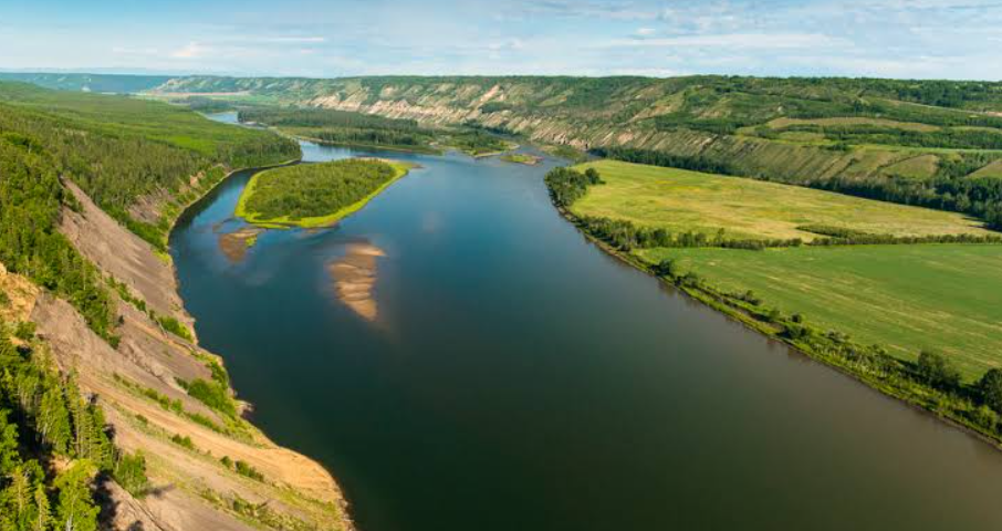
Peace River Valley is a broad, fertile river landscape extending through northeastern British Columbia and northwestern Alberta. Shaped by the Peace River and its tributaries, the valley combines deep river corridors, forested uplands, agricultural land, rolling plains, and dramatic sections where the river cuts through the surrounding plateau.
The valley has long been important to Indigenous peoples, transportation, agriculture, forestry, and resource industries. Today, communities such as Hudson’s Hope, Fort St. John, Taylor, and Peace River provide access to different parts of the region, while surrounding parks, historic sites, waterways, and scenic landscapes make the valley an interesting destination for travelers exploring northern Canada.
Peace River Valley Quick Facts
| Fact | Details |
|---|---|
| Location | Northeastern British Columbia and northwestern Alberta |
| Country | Canada |
| Region | Peace Country |
| Main River | Peace River |
| Landscape | River valley, forests, farmland and rolling plateau |
| Famous For | Agriculture, river scenery, history and northern landscapes |
| Climate | Northern continental |
| Best Months | June to September |
| Major Communities | Hudson’s Hope, Fort St. John, Taylor and Peace River |
Where Is Peace River Valley?
Peace River Valley follows the Peace River across northeastern British Columbia and into northwestern Alberta. The river begins in British Columbia after the Finlay and Parsnip rivers join at what is now Williston Lake, then flows eastward through the Peace region before continuing into Alberta.
Important communities associated with the valley include Hudson’s Hope, Fort St. John, Taylor, and the town of Peace River. The surrounding area forms part of the wider Peace Country, a region known for agriculture, forests, rivers, and resource development.
Geography and Landscape
The valley is characterized by a striking contrast between the relatively broad river corridor and the higher plateau surrounding it. In parts of British Columbia, the Peace River occupies a deep valley with steep slopes and terraces, while farther east the landscape becomes more open and agricultural.
The river’s major tributaries include the Halfway, Moberly, Pine, Beatton, and Kiskatinaw rivers. Deeply incised tributary valleys cut through the surrounding plateau, creating a varied landscape of wooded slopes, farmland, benches, and river lowlands.
Glacial activity also shaped the region. Retreating ice left extensive deposits and former lake sediments across the Peace Country, contributing to the fertile soils that support agriculture today.
History of Peace River Valley
The Peace River has been an important travel and cultural corridor for Indigenous peoples for centuries. The river’s name is associated with historical agreements between Cree and Dane-zaa (Beaver) peoples, reflecting the region’s long Indigenous history and importance as a meeting area.
European fur traders entered the region during the late eighteenth and early nineteenth centuries. The river subsequently became an important route for exploration, trading, missionary activity, and settlement.
Agriculture expanded significantly after settlement increased, particularly because the Peace Country contains some of Canada’s most productive agricultural land at this latitude. Farming, forestry, oil and gas, and hydroelectric development later became major influences on the regional economy.
The construction of infrastructure such as roads, railways, and hydroelectric facilities further connected the valley with southern British Columbia and Alberta. Today, the landscape combines working agricultural communities with protected natural areas and historic sites.
How Was Peace River Valley Formed?
The valley developed through a combination of erosion, tectonic processes, sediment deposition, and repeated glaciation. The Peace River and its tributaries gradually cut into sedimentary rocks, producing the deep channels and steep-sided valleys visible in parts of the region.
During the last ice ages, glaciers and meltwater reshaped the wider landscape. Glacial deposits and former lake sediments contributed to the fertile soils found across portions of the Peace River country, while ongoing river erosion continues to modify the valley.
Peace River Valley Weather Throughout the Year
The Peace River Valley has a northern continental climate with cold winters, relatively warm summers, and a short growing season compared with southern agricultural regions.
January to March
Winter is cold, with temperatures frequently remaining below freezing. Snow cover is normally established, and January and February are among the coldest months. March begins the transition toward spring, although winter conditions can persist.
April to June
Spring brings rapidly increasing daylight and warming temperatures. April can still be cool, while May and June become increasingly suitable for outdoor activities and agricultural work. Snowmelt and spring runoff can raise river and creek levels.
July to September
Summer is generally the warmest and most comfortable period. July and August can bring warm days, while nights remain cooler than in southern Canada. September gradually becomes more autumnal, with shorter days and falling temperatures.
October to December
Autumn brings cooler temperatures, changing foliage, and eventually the return of winter. October can have crisp, relatively mild days, while November and December increasingly bring freezing temperatures and snowfall.
Best Weather for Visiting Peace River Valley
June through September generally offers the most comfortable conditions for exploring the valley, with warmer temperatures, longer daylight hours, and better access to outdoor attractions. July and August are particularly suitable for hiking, sightseeing, camping, and river-based activities.
Things to Do in Peace River Valley
- Hiking and nature walks: Explore trails and natural areas around the river, forests, and surrounding countryside.
- Scenic driving: Road trips through Peace Country provide views of farmland, wooded hills, river corridors, and northern landscapes.
- Fishing: The Peace River and its tributaries provide opportunities for freshwater fishing, subject to local regulations.
- Wildlife watching: Forests, wetlands, agricultural edges, and river habitats support a variety of northern wildlife.
- Canoeing and kayaking: Suitable waterways offer opportunities for paddling, although river conditions should always be assessed beforehand.
- Photography: River viewpoints, historic sites, agricultural landscapes, and changing northern light provide varied photography subjects.
Famous Attractions in and Around Peace River Valley
Dunvegan Provincial Park
Located along the Peace River in Alberta, Dunvegan preserves an important historic and scenic area. Its river landscape, historic buildings, and interpretive facilities make it one of the region’s notable attractions.
Dunvegan Bridge
The historic Dunvegan Bridge crosses the Peace River and is an important piece of northern Alberta’s transportation heritage.
Kiskatinaw Bridge
Near Taylor, British Columbia, the historic Kiskatinaw Bridge is an unusual curved wooden bridge associated with the development of transportation routes through the Peace region.
Hudson’s Hope
This community sits along the Peace River in British Columbia and provides access to surrounding natural scenery and regional attractions.
Peace Canyon
The Peace Canyon area showcases the river’s deep valley landscape and the region’s hydroelectric development.
Fort St. John
Fort St. John is one of the major population centers of British Columbia’s Peace region and an important base for exploring nearby attractions and countryside.
Peace River
The Alberta town of Peace River sits along the river and provides access to viewpoints, parks, trails, and other attractions in the eastern part of the valley.
Wildlife and Nature
The valley supports a mixture of boreal forest, grassland, wetlands, river habitats, and agricultural ecosystems. Common trees include spruce, aspen, poplar, and other northern species, while riverbanks provide important habitat for birds and mammals.
Wildlife in the broader Peace River region includes moose, deer, black bears, beavers, coyotes, foxes, and numerous bird species. The combination of forests and waterways creates important ecological corridors, while protected areas help conserve habitats alongside agricultural and resource-based land uses.
How to Reach Peace River Valley
Peace River Valley is accessible primarily by road. Major highways connect the region with British Columbia’s interior and northern Alberta, including routes serving Hudson’s Hope, Fort St. John, Taylor, and Peace River.
Fort St. John Airport provides the principal scheduled air connection in the central British Columbia portion of the valley, while Grande Prairie Airport serves as an important gateway farther east. Regional communities also provide road access to individual attractions and recreation areas.
Because the region experiences significant winter conditions, travelers should check road and weather conditions before driving during the colder months.
Where to Stay Near Peace River Valley
Accommodation is available in the main communities throughout the valley and surrounding Peace Country. Fort St. John, Hudson’s Hope, Taylor, and Peace River offer hotels, motels, guesthouses, and other lodging options.
Travelers looking for a more nature-focused experience can also find campgrounds and recreational camping areas in and around parks and rural destinations. Staying in different communities can be useful for visitors planning to explore separate sections of this extensive valley.
Why Is Peace River Valley Famous?
Peace River Valley is known for its combination of a major northern river, fertile agricultural land, deep valleys, forests, Indigenous and fur-trade history, and important transportation and resource industries. Its distinctive northern landscape makes it one of the most significant geographic and cultural regions of western Canada.
Peace River Valley FAQs
Where is Peace River Valley located?
Peace River Valley extends through northeastern British Columbia and northwestern Alberta, following the course of the Peace River.
What is Peace River Valley famous for?
It is known for the Peace River, fertile farmland, northern forests, Indigenous history, agriculture, resource industries, and scenic river landscapes.
What is the weather like in Peace River Valley?
The region has a northern continental climate, with cold snowy winters, mild to warm summers, and noticeable seasonal changes.
What are the best months to visit Peace River Valley?
June through September generally offers the most comfortable weather for sightseeing and outdoor activities.
What can you do in Peace River Valley?
Visitors can hike, fish, camp, photograph the landscape, watch wildlife, explore historic sites, and enjoy scenic drives.
How do you reach Peace River Valley?
The valley is primarily accessed by road through northeastern British Columbia and northwestern Alberta. Fort St. John and Grande Prairie provide important regional transportation connections.
Does Peace River Valley get snow?
Yes. Winters are cold and snowy, and snow can remain on the ground for an extended period, particularly in the northern and higher-elevation areas.
What are the main communities in Peace River Valley?
Hudson’s Hope, Fort St. John, Taylor, and Peace River are among the most important communities associated with the valley.
Final Thoughts
Peace River Valley combines northern wilderness, fertile agricultural country, historic communities, and one of western Canada’s major rivers. Its broad landscapes and changing seasons make it a distinctive destination for travelers interested in nature, history, outdoor recreation, and the character of Canada’s Peace Country.
