
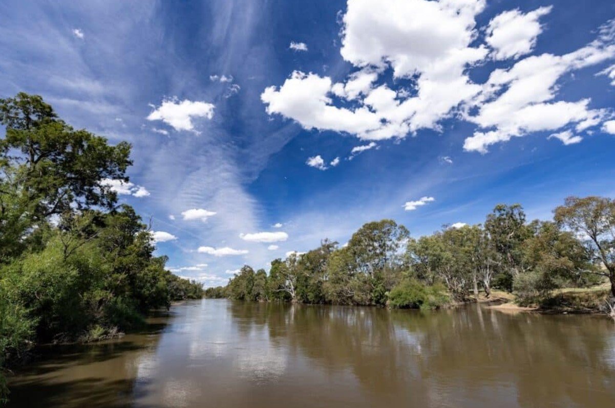
The Murrumbidgee Valley is a diverse river landscape stretching across southern New South Wales and into the Australian Capital Territory. Shaped by the Murrumbidgee River, the valley changes from mountainous country in the east to broad river plains, wetlands, forests, and agricultural areas farther west. Its waterways support both natural ecosystems and communities that depend on irrigation, farming, recreation, and tourism.
The valley is particularly known for river red gum forests, wetlands, native wildlife, and its strong connection with First Nations cultures. Towns such as Wagga Wagga, Narrandera, Leeton, Hay, and Balranald provide access to different parts of the region, while protected areas along the river offer opportunities for camping, fishing, paddling, walking, cycling, and wildlife observation.
Murrumbidgee Valley Quick Facts
| Fact | Details |
|---|---|
| Location | Southern New South Wales and Australian Capital Territory |
| Country | Australia |
| Region | Riverina and southern NSW |
| Main River | Murrumbidgee River |
| Landscape | River plains, wetlands, forests, agricultural country and mountains |
| Famous For | River red gums, wetlands, wildlife and the Murrumbidgee River |
| Climate | Varies from cooler uplands to hot, semi-arid western plains |
| Best Months | Generally spring and autumn for outdoor activities |
| Nearby Towns | Wagga Wagga, Narrandera, Leeton, Hay and Balranald |
Where Is Murrumbidgee Valley?
Murrumbidgee Valley follows the Murrumbidgee River through southern New South Wales and the Australian Capital Territory. The river begins in the Australian Alps before flowing westward across the inland plains and eventually joining the Murray River.
The valley encompasses a large and varied area rather than a single compact basin. Important communities along or near its course include Canberra, Wagga Wagga, Narrandera, Leeton, Hay, and Balranald. The western portion is part of the broader Riverina landscape and becomes increasingly dry toward the Lower Murrumbidgee.
Geography and Landscape
The Murrumbidgee Valley changes considerably from east to west. Its upper reaches pass through elevated country, while the middle and lower sections spread across flatter agricultural plains and extensive floodplains.
The Murrumbidgee River is the defining geographical feature. Along its course are river red gum forests, billabongs, lagoons, wetlands, sandy riverbanks, grasslands, and floodplain woodlands. The mid-Murrumbidgee wetlands between Wagga Wagga and Carrathool include numerous lagoons and billabongs, while the Lowbidgee Floodplain farther west contains extensive lignum wetlands.
Agriculture is also a major part of the landscape, particularly in the Riverina. Irrigation supplied by the river supports crops and other agricultural production, creating a close relationship between the natural river system and the region’s economy.
History of Murrumbidgee Valley
The Murrumbidgee Valley has a long Indigenous history. Wiradjuri people have strong traditional connections with much of the valley, while several other First Nations groups are associated with different sections of the river and its surrounding country. The river, wetlands, plants, and animals have long been important for cultural practices, food, materials, and travel.
European exploration and settlement expanded through the region during the nineteenth century. The river became important for transport, pastoral activity, agriculture, and the development of inland settlements. Later, irrigation transformed large parts of the Riverina by making reliable water available for farming.
Today, the valley combines agricultural communities with protected natural areas. Conservation programs increasingly focus on maintaining river flows, wetlands, floodplain forests, and habitats while balancing environmental requirements with water use and agriculture.
How Was Murrumbidgee Valley Formed?
The valley developed through the long-term interaction of the Murrumbidgee River with the surrounding landscape. River erosion, sediment deposition, flooding, and changes in the river’s course gradually shaped its floodplains, channels, billabongs, and wetlands.
In the lower and middle sections, periodic flooding has been especially important in maintaining river red gum forests and wetland ecosystems. The broader landscape also reflects the gradual movement of water and sediment across the inland plains.
Murrumbidgee Valley Weather Throughout the Year
Murrumbidgee Valley weather varies considerably because the region extends from cooler elevated areas near the Australian Alps to much hotter and drier plains in western New South Wales. Conditions in the lower valley are particularly warm during summer and relatively cool in winter.
January to March
Summer is generally hot, especially across the western and central parts of the valley. In the Murrumbidgee Valley National Park area, average summer temperatures are approximately 16°C to 32°C, although extreme temperatures can be considerably higher. Early mornings and late afternoons are usually more comfortable for outdoor activities.
April to June
Autumn brings milder days and cooler evenings, making it one of the more comfortable periods for camping, walking, and exploring the river. Rainfall can vary, but May is among the wetter months in the lower valley. By June, winter conditions begin to develop.
July to September
Winter brings cool days and cold nights, with frost possible in inland areas. In the lower Murrumbidgee Valley National Park area, average winter temperatures are around 4°C to 16.5°C. Spring begins to warm the landscape in September, while morning mist and increased wildlife activity can occur around river environments.
October to December
Spring and early summer bring rising temperatures and longer days. October and November are generally suitable for outdoor recreation, although heat becomes increasingly important toward December. Spring can also be a rewarding period for birdwatching and observing native wildlife.
Best Weather for Visiting Murrumbidgee Valley
Spring and autumn are generally the most comfortable periods for exploring the valley, particularly for walking, camping, cycling, and wildlife watching. Summer can suit water-based activities, but visitors should plan around the hottest parts of the day.
Things to Do in Murrumbidgee Valley
- Canoeing and kayaking: Paddle sections of the Murrumbidgee River and explore its quieter waterways.
- Fishing: River and wetland environments provide opportunities for recreational fishing where permitted.
- Hiking and walking: Trails through river red gum forests and reserves offer easy ways to explore the landscape.
- Cycling: Selected park trails and riverside areas are suitable for cycling and exploring by bike.
- Camping: Riverside campgrounds provide a closer experience of the valley’s bushland and wildlife.
- Birdwatching: Wetlands, lagoons, and river forests attract a wide range of native and migratory birds.
- Swimming and boating: Some designated river areas provide opportunities for swimming and boating, subject to local conditions and safety advice.
Famous Attractions in and Around Murrumbidgee Valley
Murrumbidgee Valley National Park
This protected area follows sections of the river and preserves extensive river red gum country. It includes camping areas, walking routes, fishing locations, and places for paddling.
Murrumbidgee Valley Regional Park
Located around Narrandera and Darlington Point, the regional park combines river frontage, sandy beaches, forests, camping areas, and recreational access.
Murrumbidgee Valley Nature Reserve
Near Narrandera, this reserve is particularly notable for its koala population and river red gum habitat.
Turkey Flat
Turkey Flat near Leeton features a picnic area, bird hide, walking trail, and access to the surrounding river landscape.
Middle Beach
This riverside location provides a scenic setting for swimming, paddling, picnicking, and enjoying the Murrumbidgee River.
Lowbidgee Floodplain
The Lower Murrumbidgee, or Lowbidgee, Floodplain is an extensive wetland and floodplain system containing important lignum wetlands and wildlife habitat.
Fivebough and Tuckerbil Swamps
Near Leeton, these internationally significant wetlands are important habitats for waterbirds and provide valuable opportunities for nature observation.
Wildlife and Nature
The Murrumbidgee Valley supports a diverse range of wildlife because its river, wetlands, forests, and floodplains provide different habitats. River red gum forests are particularly important, while lagoons and wetlands provide breeding and feeding areas for waterbirds.
Koalas are a notable feature of the region, especially around Murrumbidgee Valley Nature Reserve near Narrandera. Grey kangaroos, eastern rosellas, galahs, sulphur-crested cockatoos, kingfishers, and other birds can also be seen. The wider valley supports significant species including southern bell frogs, Australasian bitterns, Murray cod, trout cod, and silver perch.
How to Reach Murrumbidgee Valley
Access depends on which section of the valley you want to visit. Major regional roads connect the valley with Wagga Wagga, Narrandera, Leeton, Hay, and Balranald, while Canberra provides access to the upper Murrumbidgee region.
Wagga Wagga Airport is the main regional airport for central sections, while Canberra Airport is useful for the eastern end of the valley. Rail services operate to several regional communities, including Wagga Wagga and Griffith connections, with road travel required for many riverside reserves and parks.
Some national park access roads are unsealed and may be restricted after wet weather, so current road conditions should be checked before traveling.
Where to Stay Near Murrumbidgee Valley
Accommodation varies widely across this large region. Wagga Wagga, Narrandera, Leeton, Hay, and Balranald provide hotels, motels, guesthouses, and other town-based accommodation.
For a more natural experience, visitors can use designated campgrounds within the Murrumbidgee Valley National Park and Regional Park. Riverside camping is particularly suited to travelers interested in fishing, paddling, wildlife, and quiet bush surroundings.
Why Is Murrumbidgee Valley Famous?
Murrumbidgee Valley is famous for the river that connects its contrasting landscapes, from alpine country and agricultural plains to extensive wetlands and river red gum forests. Its combination of Indigenous cultural heritage, wildlife habitat, irrigation agriculture, and outdoor recreation gives the valley an important place in the natural and cultural geography of southern Australia.
Murrumbidgee Valley FAQs
Where is Murrumbidgee Valley located?
Murrumbidgee Valley extends through southern New South Wales and the Australian Capital Territory, following the Murrumbidgee River from the Australian Alps toward the Murray River.
What is Murrumbidgee Valley famous for?
It is known for the Murrumbidgee River, river red gum forests, wetlands, agriculture, wildlife, Indigenous heritage, and outdoor recreation.
What is the weather like in Murrumbidgee Valley?
The climate varies along the valley. Summers are generally hot, while winters are cooler, particularly farther east and at higher elevations.
What are the best months to visit Murrumbidgee Valley?
Spring and autumn generally offer comfortable conditions for walking, camping, cycling, and wildlife watching. Summer can also be enjoyable for selected river activities.
What can you do in Murrumbidgee Valley?
Visitors can hike, cycle, camp, fish, paddle, swim in suitable locations, photograph the landscape, and observe wildlife and birds.
How do you reach Murrumbidgee Valley?
The valley is accessible by road from regional centers including Wagga Wagga, Narrandera, Leeton, Hay, and Balranald. Canberra is a useful gateway to its eastern section.
Does Murrumbidgee Valley get cold in winter?
Yes. Winter nights can be cold, particularly inland and in elevated areas, with frost possible in parts of the valley.
Can you see koalas in Murrumbidgee Valley?
Yes. Murrumbidgee Valley Nature Reserve near Narrandera is particularly well known for its koala population and provides a designated walking track through river red gum habitat.
Final Thoughts
Murrumbidgee Valley offers a distinctive combination of river landscapes, wetlands, forests, agricultural country, wildlife, and cultural heritage. Its large geographic range means visitors can experience very different environments along the same river, making it an important natural and regional landscape to explore.
For More Visit Stay And Update
